Devereaux Cove Fieldwork 2000
Home        View the site map         Read a complete chapter on the site's archaeology (PDF file)

Project Objectives
The primary aim of the 2000 Devereaux Cove project was to conduct a Phase II archaeological survey of wooden vessel remains located along Devereaux Cove’s northeastern shoreline and to document visible remains using mapping and photographic techniques.  Archaeological data generated by this reconnaissance level survey determined the extent of intact hull structure and established the shipwreck’s current state of preservation.  Secondary goals were to determine the site's potential for further archaeological investigation, develop a management plan, begin the process of nominating the shipwreck to the National Register of Historic Places, and, through archaeological and historical research, determine the shipwreck’s association with the Penobscot Expedition of 1779
Maine and Penobscot Bay

The Site
Named for the tidal cove within which it rests, the Devereaux Cove vessel is located in Stockton Springs, Waldo County, Maine.
Devereaux Cove is one of five small coves located along the north-northwestern shoreline of Fort Point Cove, on the west side of Penobscot Bay at the mouth of the Penobscot River.  Approximately one quarter of a mile wide at its entrance, Devereaux Cove is a shallow tidal flat, roughly 3 feet deep at mean low tide. The Devereaux Cove wreck lies in the northeast portion of the cove, approximately 50 feet from the high water mark, and is completely exposed at low tide. Positioned with a northwest to southeast orientation, the visible remains cover a 52 foot by 12 foot area, and to the casual observer are hardly discernable as the remains of a wooden vessel.  While interviewing local residents, it was interesting to note that at least one family was completely unaware that the “drift wood” within the cove is actually the remains of a wooden ship.  The visible remains are comprised of floors and first futtocks (lower frame timbers), none of which are preserved in their entirety.  The timbers are embedded in thick mud and protrude roughly 2 inches above the mud line. The sided (exposed) surfaces of the timbers are eroded significantly, resulting in a fragile archaeological surface riddled with channels worn into the timbers over years of tidal exchange and harsh weather.  The inboard ends of treenails (wooden fasteners used to attach the outer hull planking to the frames) are clearly evident. The dynamic site environment has resulted in the exposed (inboard) ends of many treenails becoming pointed, with a circular depression surrounding the treenail itself.

Click to Enlarge
Devereaux Cove flooded Devereaux Cove at low tide Mapping
            The Devereaux Cove site at nearly high tide.                                        The site at low tide.      Frame timbers that comprised the very bottom of the vessel

Because the Devereaux Cove Wreck is located in a tidal flat, the visible remains are left dry at low tide and completely submerged at high tide.  Consequently, the vessel’s exposed timbers become waterlogged during high tide, only to partially dry out when exposed at low tide.  This circumstance accelerates decomposition of the exposed timbers. The region’s average year round temperature is 45º Fahrenheit (F), with winter temperatures averaging 20º F. The resultant ice formation, and repeated expansion and contraction of the waterlogged timbers further compromises their structural integrity.  Ice formation also produces "rafting,” a condition where loose timbers may be worked free of the site as the ice they are attached to shifts with the tide. The exposed timbers are also perpetually eroded by the daily tidal exchange and the constant movement of water over the timber’s sided surfaces.  Those timbers not firmly ensconced in the mud bottom or attached to a more substantial part of the wreck are subject to being dislodged and carried away with the tide.

Floor timber
Frame timber. The wooden dowels (trunnels) along the centerline were used to attach hull planking.
Mapping
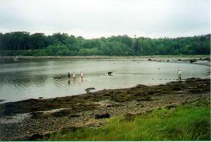
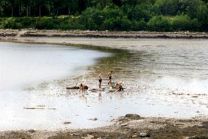
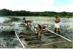
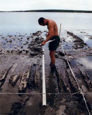
Mapping the Devereaux Cove Wrecks's floors and first futtocks (the bottom most frame timbers).

Notably, the shoreward portion of the vessel is considerably less intact than the open water side, suggesting that the wreck initially listed toward open water, leaving shoreward frames more exposed to the elements and tide.  Extant outer hull planking on the vessel’s shoreward side, now free of frame timbers, suggests that when the wreck came to rest in Devereaux Cove, more frame timbers were present.     

The wrecking event, contemporary salvage, and modern artifact collecting must also be considered for their impact on the site formation process.  If the Devereaux Cove vessel is a Penobscot Expedition transport, run aground and burned to prevent capture, it likely burned well below the waterline after the tide ran out.  Moreover, should the remains at Devereaux Cove be the carcass of a transport burned at a nearby location only to drift to the present site, that process too would have further compromised the wreck’s structure.  Like 
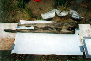
other beached expedition transports, the Devereaux Cove vessel likely represented a windfall of iron, and depending on the extent of its initial destruction, building timber for local inhabitants.  That locals may even have re-burned the wreck to claim every valuable iron fastener, is not inconceivable.  Finally, because of the wreck’s close proximity to shore, modern human impact on the site, in the form of souvenir hunting or mere curiosity, likely ensured the loss of easily portable timbers, planks, or artifacts.  Clearly, much of the vessel has been lost via all, or a combination of, the environmental and human impacts described above.  It should be noted, however, that anaerobic conditions well below the mud line appear to have slowed deterioration of some buried hull structure.  Learn more about 
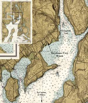
the Devereaux Cove and what archaeologists found (PDF file).

Home            View a map of the wreck          Read about the Penobscot Expedition of 1779